


307P1 - PRESTON 1 Voting District, Webster County, Georgia
About
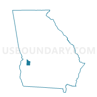
Outline

Summary
| Unique Area Identifier | 563108 |
| Name | 307P1 - PRESTON 1 Voting District |
| County | Webster County |
| State | Georgia |
| Area (square miles) | 75.93 |
| Land Area (square miles) | 75.60 |
| Water Area (square miles) | 0.33 |
| % of Land Area | 99.57 |
| % of Water Area | 0.43 |
| Latitude of the Internal Point | 32.11546250 |
| Longtitude of the Internal Point | -84.59369170 |
Maps


Graphs
Select a template below for downloading or customizing gragh for 307P1 - PRESTON 1 Voting District, Webster County, Georgia


Neighbors
Neighoring Voting District (by Name) Neighboring Voting District on the Map
- 197034 - DRANEVILLE Voting District, Marion County, GA
- 197807 - BUENA VISTA Voting District, Marion County, GA
- 25902 - RICHLAND Voting District, Stewart County, GA
- 307G3 - GOOSEBERRY 3 Voting District, Webster County, GA
- 307P3 - PRESTON 3 Voting District, Webster County, GA
- 307W2 - WESTON 2 Voting District, Webster County, GA
Top 10 Neighboring County Subdivision (by Population) Neighboring County Subdivision on the Map
- Buena Vista CCD, Marion County, GA (4,219)
- Richland CCD, Stewart County, GA (1,976)
- Weston CCD, Webster County, GA (1,408)
- Preston CCD, Webster County, GA (1,391)
Top 10 Neighboring Place (by Population) Neighboring Place on the Map
Top 10 Neighboring Unified School District (by Population) Neighboring Unified School District on the Map
- Marion County School District, GA (8,742)
- Stewart County School District, GA (6,058)
- Webster County School District, GA (2,799)
Top 10 Neighboring State Legislative District Lower Chamber (by Population) Neighboring State Legislative District Lower Chamber on the Map
Top 10 Neighboring State Legislative District Upper Chamber (by Population) Neighboring State Legislative District Upper Chamber on the Map
Top 10 Neighboring 111th Congressional District (by Population) Neighboring 111th Congressional District on the Map
Top 10 Neighboring Census Tract (by Population) Neighboring Census Tract on the Map
- Census Tract 9202, Marion County, GA (4,219)
- Census Tract 9501, Stewart County, GA (1,976)
- Census Tract 9602, Webster County, GA (1,408)
- Census Tract 9601, Webster County, GA (1,391)